It delivers what it promises…
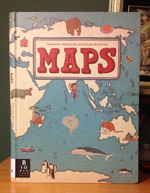
I love coffee table books. They’re just these huge, panoramic sources of information and, as a kid, I particularly loved them because, in addition to being beautiful, they also seemed like something that belonged to the world of parents. There’s something about a kid reading an over-sized coffee table book that just feels subversive, like the kid is somehow reaching above their station and accessing forbidden knowledge. That is one of many reasons why I found impossible to resist buying my daughter a copy of Maps by Aleksandra Mizielińska and Daniel Mizieliński, a gorgeous world atlas by Big Picture Press that’s so beautiful, you’ll want to frame every two-page spread and hang it on your wall.
I encountered Maps for the first time last week during an impromptu trip to New York City. I had some time to kill, so I found myself browsing the New York Public Library (OK, I’ll admit, I was doing a self-guided Ghostbusters walking tour) and I saw Maps in the gift shop. After two minutes of flipping through it, I was hooked and it became my daughter’s souvenir from my trip.
Maps isn’t an exhaustive world atlas. It features 52 maps – including hand-drawn maps of all seven continents and individual maps of several major countries in each. (North America, Antarctica, and Australia are easily served, while the rest of the continents only get featured selections.) While that might rankle any completists out there, I should say that Maps isn’t trying to be an exhaustive cartography resource. There are other atlases for that (or even apps). What Maps is trying to accomplish is a little more interesting and a little harder to do. It’s trying to give kids a taste of what the rest of the world is like. It’s trying, through art, to convey a sense of what these countries are all about. Which is ambitious to say the least, but I think it largely accomplishes its goals.

Click to expand this to something closer to its in-person glory…
Each country gets a two-page spread and, in addition to the country’s rivers and borders, Mizielińska and Mizieliński populate each map with an exhaustive series of icons and details that call out some of the distinguishing features of the country in question. The marginal illustrations show you what the people look like, they recount the country’s history, they show you the food, the flora, the fauna – each map really does try to show young readers how each country FEELS, which is a lot more impressive to me than any topography or latitude-and-longitude map. [read the rest of the post…]
{ 3 comments }